Glove / Statistics
How many governments tax a commercial property?
Not one. In Harris County, Texas a commercial account carries on average 8.82 taxing jurisdictions, and more than a third of its commercial accounts sit in no city at all. In Davidson County, Tennessee three in five parcels inside a separately incorporated city carry a property address that names a different city. In the Charleston tri-county area of South Carolina a single county carries 44 distinct tax districts. This page collects the counted jurisdiction figures from seven markets in five states in one place, each with its number, its market, its source file and its date. Seven markets, chosen because Glove covers them — a commercial reason, not a statistical one — so nothing here is a national figure.
Key takeaways
Counted jurisdiction figures from seven markets in five states, each one counted rather than estimated, each written to stand alone if you quote only the line. Market, source and date are attached to every one.
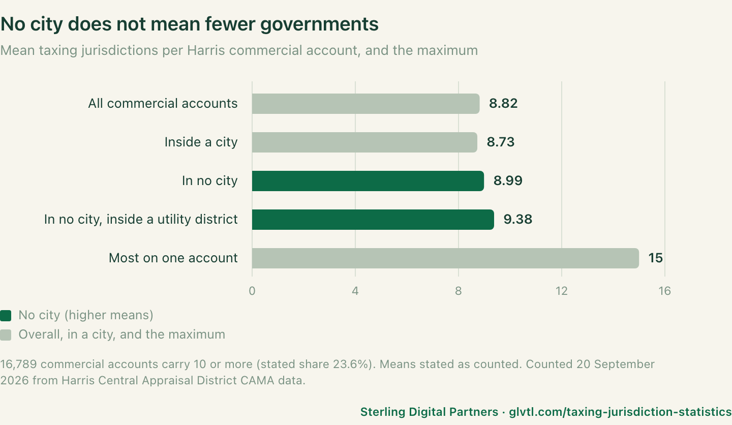
- A commercial account in Harris County, Texas carries on average 8.82 taxing jurisdictions, and the most-loaded account carries 15.
Harris Central Appraisal District 2026 CAMA public data, counted 20 September 2026. Rows
mean_taxing_jurisdictionsandmax_taxing_jurisdictions, CSV · study No. 04 - 23.6% of Harris County commercial accounts are taxed by 10 or more jurisdictions — 16,789 accounts — and 99.8% are taxed by 7 or more.
Harris Central Appraisal District 2026 CAMA public data, counted 20 September 2026. Rows
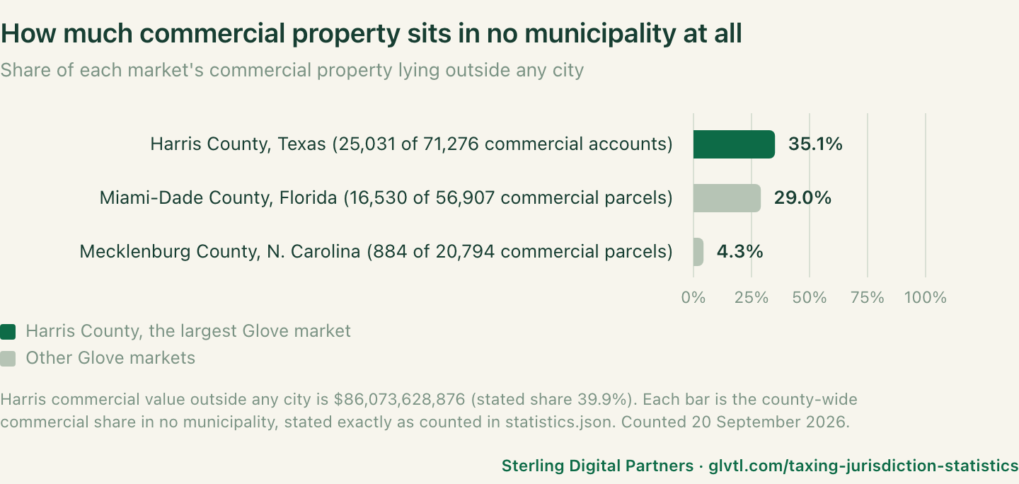
commercial_taxed_by_10_or_moreandcommercial_taxed_by_7_or_more, CSV · study No. 04 - 35.1% of Harris County commercial accounts sit in no city at all — 25,031 of 71,276 — holding $86.07bn of appraised value, 39.9% of the commercial total.
Harris Central Appraisal District 2026 CAMA public data, counted 20 September 2026. Rows
commercial_in_no_cityandvalue_no_city_usd, CSV · study No. 04 - 748 distinct taxing districts touch commercial property in Harris County, 69.4% of the 1,078 in the table; 31 cities hold commercial accounts and 398 utility districts hold commercial accounts that sit in no city.
Harris Central Appraisal District 2026 CAMA public data, counted 20 September 2026. Rows
taxing_districts_on_commercial,cities_holding_commercialandutility_districts_holding_no_city_commercial, CSV · study No. 04 - 29.0% of Miami-Dade County commercial parcels are in unincorporated county — 16,530 of 56,907 — against 42.1% of the whole roll.
Florida DOR 2026 preliminary assessment roll, roll generated 1 July 2026, counted 20 September 2026. Rows
jurisdiction_unincorporated_commercialandjurisdiction_unincorporated_roll, CSV · study No. 02 - 23.9% of Mecklenburg County commercial parcels are outside the City of Charlotte — 4,965 of 20,794 — of which 884 have no municipal government at all.
Mecklenburg County, NC open bulk data, files dated 14 and 15 September 2026, counted 20 September 2026. Rows
jurisdiction_commercial_not_charlotteandjurisdiction_commercial_unincorporated, CSV · study No. 03 - 66.8% of Sarasota County commercial parcels with a Sarasota address are in unincorporated county — 4,301 of 6,442.
Sarasota County Property Appraiser parcel file, counted 19 September 2026. Row
sarasota_situs_commercial_unincorporated, CSV · study No. 01 - 82.4% of Manatee County parcels fall outside every municipal tax district — 194,828 of 236,531 — and of 4,186 commercial parcels with a Bradenton address, 72.1% are unincorporated.
Florida DOR 2026 preliminary roll for Manatee, files dated 27 July 2026, counted 20 September 2026. Rows
manatee_parcels_unincorporatedandmanatee_bradenton_situs_commercial_unincorporated, CSV · study No. 01 - All 917 commercial parcels on Manatee County’s roll with a Sarasota address are unincorporated — addressed to one county’s city, taxed by another county’s county.
Florida DOR 2026 preliminary roll for Manatee, files dated 27 July 2026, counted 20 September 2026. Row
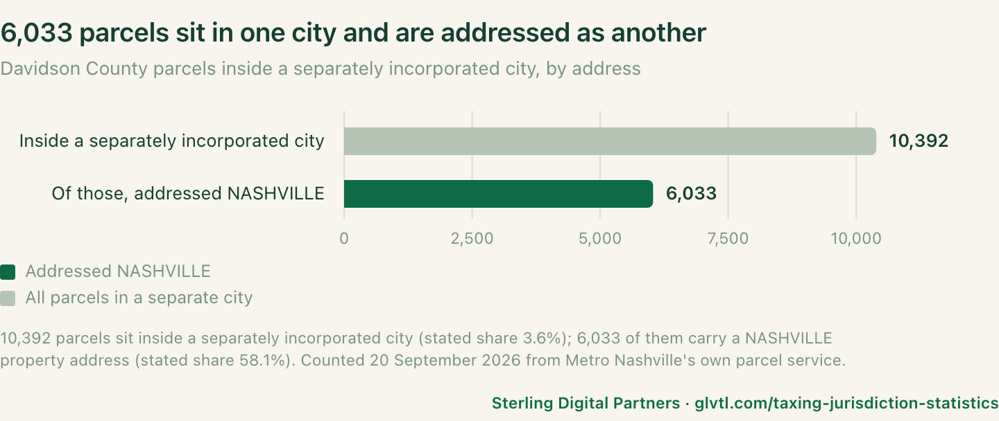
manatee_sarasota_situs_commercial_unincorporated, CSV · study No. 01 - 58.1% of Davidson County parcels inside a separately incorporated city carry a NASHVILLE property address — 6,033 of 10,392 — including all 929 parcels in Berry Hill and all 1,225 in Belle Meade.
Metro Nashville / Davidson County public ArcGIS parcel service, counted 20 September 2026. Rows
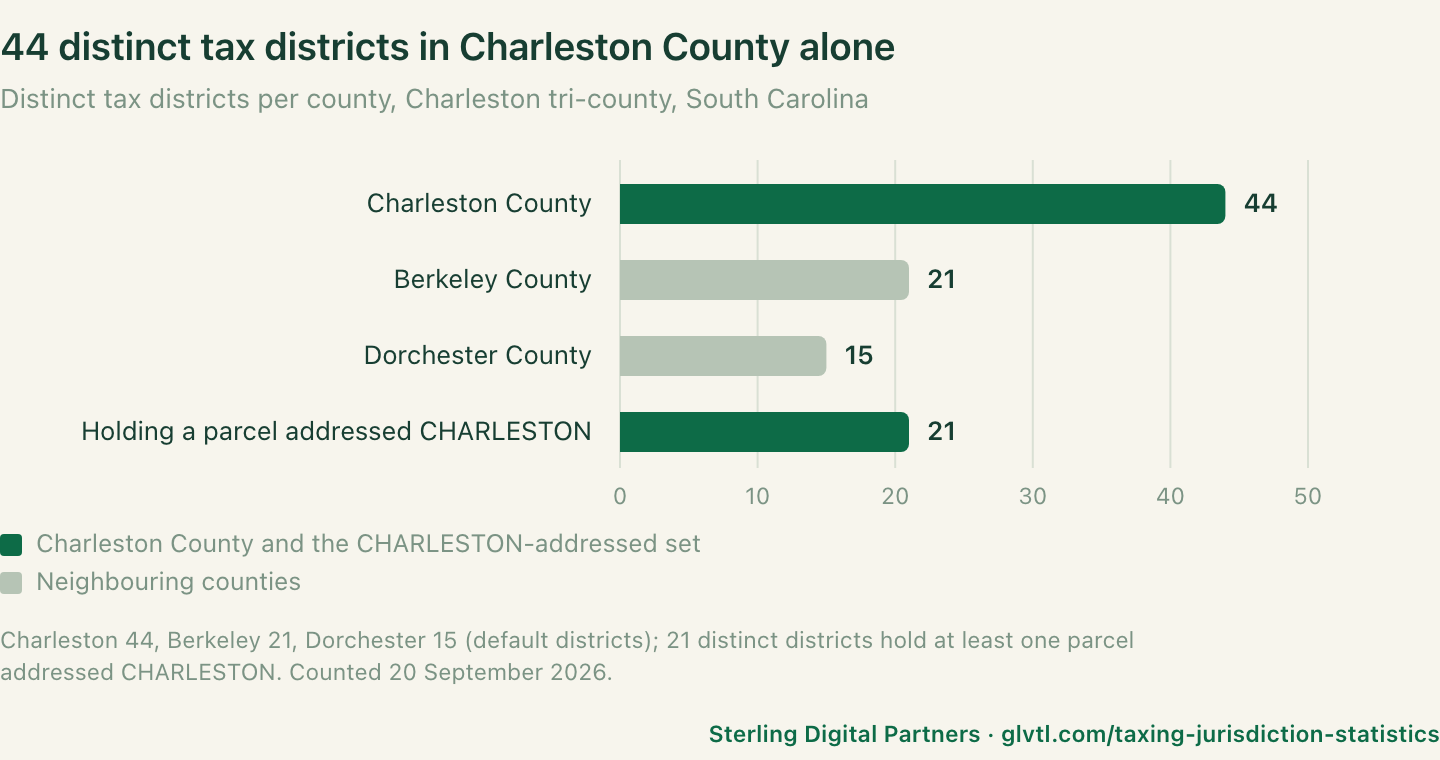
Parcels in a separate city but addressed NASHVILLE,Berry Hill parcels with a NASHVILLE property addressandBelle Meade parcels with a NASHVILLE property address, CSV · study No. 06 - Charleston County, South Carolina carries 44 distinct tax districts, Berkeley County 21 and Dorchester County 15 — and 63,820 parcels addressed CHARLESTON sit across 21 of them.
Charleston, Berkeley and Dorchester county public ArcGIS parcel services, counted 20 September 2026. Rows
Charleston distinct tax districts,Berkeley distinct tax districts,Dorchester distinct default tax districts,Charleston parcels addressed CHARLESTONandTax districts holding a parcel addressed CHARLESTON, CSV · study No. 05 - Of Harris County’s no-city commercial accounts, 12,665 sit in a utility district and 12,366 sit under the county only — 17.8% and 17.3% of the commercial stock — and the utility-district group carries the heaviest load in the county at 9.38 jurisdictions on average.
Harris Central Appraisal District 2026 CAMA public data, counted 20 September 2026. Rows
no_city_in_utility_district,no_city_county_onlyandmean_taxing_jurisdictions_no_city_in_utility, CSV · study No. 04
Question 01
How many taxing jurisdictions does a commercial property pay?
In Harris County, Texas the answer is on average 8.82 per commercial account, rising to 15 on the most-loaded account — and 23.6% of commercial accounts are taxed by 10 or more jurisdictions.
A Harris County commercial account is rarely taxed by one government. The county’s appraisal district records every taxing jurisdiction against every account, and the count counted them: the mean across 71,276 commercial accounts is 8.82 jurisdictions, the maximum on any one account is 15, and 71,143 of 71,276 — 99.8% — carry 7 or more.
Being inside a city does not lighten the load. Accounts in a city carry on average 8.73 jurisdictions; accounts in no city carry 8.99; and no-city accounts inside a utility district carry 9.38, the heaviest group in the county. The municipality is one layer among many, not a substitute for the rest.
<a href="https://glvtl.com/taxing-jurisdiction-statistics/#f1">
  <img src="https://glvtl.com/assets/jurisdiction-harris-layers.png" alt="A Harris County, Texas commercial account carries on average 8.82 taxing jurisdictions and up to 15: 99.8 percent carry 7 or more and 23.6 percent carry 10 or more." width="720" height="480">
</a>
<p><a href="https://glvtl.com/taxing-jurisdiction-statistics/#f1">Source: Sterling Digital Partners, taxing jurisdiction statistics</a> (vector version: https://glvtl.com/assets/jurisdiction-harris-layers.svg)</p>
Sources: Harris CSV rows mean_taxing_jurisdictions, max_taxing_jurisdictions, mean_taxing_jurisdictions_in_city, mean_taxing_jurisdictions_no_city, mean_taxing_jurisdictions_no_city_in_utility, commercial_taxed_by_10_or_more, commercial_taxed_by_7_or_more. Harris Central Appraisal District 2026 CAMA public data, counted 20 September 2026. If your CMS strips SVG files, use the PNG above; the SVG is the same chart at the same path with an .svg extension.
Question 02
How much commercial property is inside no municipality at all?
More than a third in Harris County — 35.1% of commercial accounts, holding 39.9% of commercial appraised value — and the share is higher still in the Florida counties: 82.4% of all Manatee County parcels sit outside every municipal tax district.
In Harris County, 25,031 of 71,276 commercial accounts — 35.1% — sit in no city, and they hold $86,073,628,876 of appraised value, 39.9% of the commercial total. Of those no-city accounts, 12,665 sit in a utility district and 12,366 sit under the county only. The no-city property is worth proportionally more than its count suggests.
In Miami-Dade County, 16,530 of 56,907 commercial parcels — 29.0% — are in unincorporated county, against 395,369 of 938,308 parcels on the whole roll, 42.1%. Commercial property is less likely than the average parcel to sit outside a municipality, but nearly a third of it does.
In Manatee County, 194,828 of 236,531 parcels — 82.4% — fall outside every one of the county’s seven municipal tax districts, leaving 41,703 inside. Of 4,186 commercial parcels with a Bradenton situs address, 3,019 — 72.1% — are unincorporated. In Sarasota County, 4,301 of 6,442 commercial parcels with a Sarasota address — 66.8% — are unincorporated.
In Mecklenburg County, 4,965 of 20,794 commercial parcels — 23.9% — are outside the City of Charlotte, spread across six towns and unincorporated county, of which 884 — 4.3% of the commercial stock — have no municipal government at all. Across all 428,758 parcels, 31,950 — 7.5% — are unincorporated.
<a href="https://glvtl.com/taxing-jurisdiction-statistics/#f2">
  <img src="https://glvtl.com/assets/jurisdiction-no-city-by-market.png" alt="Share of commercial property in no municipality at all: 35.1 percent of Harris County commercial accounts (25,031 of 71,276), 29.0 percent of Miami-Dade commercial parcels (16,530 of 56,907), and 4.3 percent of Mecklenburg County commercial parcels (884 of 20,794)." width="720" height="480">
</a>
<p><a href="https://glvtl.com/taxing-jurisdiction-statistics/#f2">Source: Sterling Digital Partners, taxing jurisdiction statistics</a> (vector version: https://glvtl.com/assets/jurisdiction-no-city-by-market.svg)</p>
Sources: Harris CSV rows commercial_in_no_city, value_no_city_usd, no_city_in_utility_district, no_city_county_only · Miami-Dade CSV rows jurisdiction_unincorporated_commercial, jurisdiction_unincorporated_roll · Sarasota CSV row sarasota_situs_commercial_unincorporated and Manatee rows manatee_parcels_unincorporated, manatee_parcels_incorporated, manatee_bradenton_situs_commercial_unincorporated · Mecklenburg CSV rows jurisdiction_commercial_not_charlotte, jurisdiction_commercial_unincorporated, jurisdiction_all_parcels_unincorporated. Counted 19–20 September 2026. If your CMS strips SVG files, use the PNG above; the SVG is the same chart at the same path with an .svg extension.
Question 03
Does a property’s address tell you which government taxes it?
No — 6,033 Davidson County parcels sit inside a separately incorporated city but carry a NASHVILLE property address, 58.1% of all parcels in such cities, and 63,820 parcels addressed CHARLESTON sit across 21 distinct tax districts.
In Davidson County, Tennessee, 10,392 parcels — 3.6% of the county — sit inside a separately incorporated city, and 6,033 of them — 58.1% — carry a NASHVILLE property address rather than the name of the city that governs them. All 929 parcels in Berry Hill and all 1,225 in Belle Meade are addressed NASHVILLE; in Forest Hills 1,959 of 2,137 (91.7%) and in Oak Hill 1,920 of 2,034 (94.4%). A reader who filters on the address city will assign these parcels to the wrong government.
In the Charleston tri-county area, 63,820 parcels carry a situs address of CHARLESTON, and they sit across 21 distinct tax districts — the address names one place and the tax districts number twenty-one. The same failure crosses a county line in Florida: 917 commercial parcels on Manatee County’s roll carry a Sarasota situs city, and all 917 — 100.0% — are unincorporated Manatee County property, taxed by no Sarasota government at all.
<a href="https://glvtl.com/taxing-jurisdiction-statistics/#f3">
  <img src="https://glvtl.com/assets/jurisdiction-address-vs-government.png" alt="Parcels in a separate city but addressed as the big city: 6,033 of 10,392 Davidson County parcels in separately incorporated cities carry a NASHVILLE address, including every parcel in Berry Hill and Belle Meade; 63,820 parcels addressed CHARLESTON sit across 21 tax districts." width="720" height="480">
</a>
<p><a href="https://glvtl.com/taxing-jurisdiction-statistics/#f3">Source: Sterling Digital Partners, taxing jurisdiction statistics</a> (vector version: https://glvtl.com/assets/jurisdiction-address-vs-government.svg)</p>
Sources: Nashville CSV rows Parcels inside a separately incorporated city, Parcels in a separate city but addressed NASHVILLE, Berry Hill parcels with a NASHVILLE property address, Belle Meade parcels with a NASHVILLE property address, Forest Hills parcels with a NASHVILLE property address, Oak Hill parcels with a NASHVILLE property address · Charleston CSV rows Charleston parcels addressed CHARLESTON, Tax districts holding a parcel addressed CHARLESTON · Sarasota CSV row manatee_sarasota_situs_commercial_unincorporated. Counted 20 September 2026. If your CMS strips SVG files, use the PNG above; the SVG is the same chart at the same path with an .svg extension.
Question 04
How many distinct tax districts does a single county carry?
Dozens: 44 distinct tax districts in Charleston County, 21 in Berkeley and 15 default districts in Dorchester — while Harris County runs 1,078 taxing districts in its table, of which 748 touch commercial property.
In the Charleston tri-county area, the district is the unit that sets the bill, and there are 44 of them in Charleston County, 21 in Berkeley County and 15 default districts in Dorchester County, across three adjacent counties covering 395,283 parcels. Twenty-one of those districts hold at least one parcel addressed CHARLESTON.
In Harris County, the appraisal district’s table holds 1,078 taxing districts in total, and 748 of them — 69.4% — tax at least one commercial account. Thirty-one of the 34 city codes in the table’s city block hold commercial accounts (91.2%), and 398 utility districts hold commercial accounts that sit in no city (61.1%). In Davidson County, the TaxDist column stores 22 distinct values as written and 15 once trimmed of stray whitespace — 43,132 parcels, 15.0% of the roll, carry a value with stray whitespace.
<a href="https://glvtl.com/taxing-jurisdiction-statistics/#f4">
  <img src="https://glvtl.com/assets/jurisdiction-district-counts.png" alt="Distinct tax districts per county: 44 in Charleston County, 21 in Berkeley County, 15 default districts in Dorchester County, and 748 of 1,078 Harris County taxing districts touching commercial property." width="720" height="480">
</a>
<p><a href="https://glvtl.com/taxing-jurisdiction-statistics/#f4">Source: Sterling Digital Partners, taxing jurisdiction statistics</a> (vector version: https://glvtl.com/assets/jurisdiction-district-counts.svg)</p>
Sources: Charleston CSV rows Charleston distinct tax districts, Berkeley distinct tax districts, Dorchester distinct default tax districts · Harris CSV rows taxing_districts_in_table, taxing_districts_on_commercial, cities_holding_commercial, utility_districts_holding_no_city_commercial · Nashville CSV rows Distinct TaxDist values as the column stores them, Distinct TaxDist values once trimmed, Parcels whose TaxDist carries stray whitespace. Counted 20 September 2026. If your CMS strips SVG files, use the PNG above; the SVG is the same chart at the same path with an .svg extension.
Question 05
Why does this vary so much between states?
Because the layers themselves are different creatures in each state: Texas builds utility districts where there is no city, Florida leaves most land unincorporated under the county, Tennessee runs a metro government ringed by separately incorporated cities, and South Carolina bills through dozens of tax districts — and each of those structures is visible directly in the counts.
The studies do not offer a causal theory beyond what their own files show, and neither does this page. What the files show is four different answers to the same question. In Harris County, the unit that multiplies is the utility district: 398 of them hold commercial accounts that sit in no city, and the no-city accounts inside a utility district carry the heaviest load measured anywhere, 9.38 jurisdictions on average. Where Texas does not incorporate, it creates districts.
In Florida, the unit that dominates is the unincorporated county itself: 82.4% of Manatee parcels and 42.1% of the Miami-Dade roll sit outside every municipality, governed and taxed by the county. In Davidson County, the structure is inverted — one metro government covering nearly everything, with 10,392 parcels in separately incorporated cities whose addresses still read NASHVILLE. In South Carolina, the multiplying unit is the tax district: 44 in one county alone.
None of this is a claim about why legislatures designed it so. It is what the parcel files contain when counted: different states stack different layers, so the same commercial building pays a different number of governments depending on which state it stands in.
This section interprets only the rows already cited under f1–f4; it introduces no new figure. Structures named here — utility districts, unincorporated county, separately incorporated cities, tax districts — are the categories the source files themselves publish.
Question 06
Can these figures be cited as national statistics?
No. Every number on this page is a count of seven named markets on stated dates, and nothing here has been weighted, modelled or projected to any larger population.
Seven markets is not a sample of the United States. It is not a sample of Texas, Florida, South Carolina or Tennessee either. The seven were chosen because Glove covers them, which is a commercial reason and not a statistical one — and a page built on commercially chosen markets cannot support a national sentence.
Cite these as what they are: “in Harris County, Texas, a commercial account carries on average 8.82 taxing jurisdictions”, not “US commercial property pays 8.82 governments”. The second sentence is not supported by anything on this page. The same applies to every figure here: each belongs to its market, its file and its date.
What the seven markets do jointly support is narrower and still useful: in every county record the series has examined, a commercial property’s tax bill is split across overlapping layers rather than levied by one government, a large share of commercial property sits in no municipality at all, and the address on the property is an unreliable guide to which governments those layers are.
Question 07
Where can I download the underlying data?
Every jurisdiction figure on this page is published as a single JSON file under CC BY 4.0, free to reuse commercially with attribution.
Each row carries the market, the metric name, the value, the denominator, the share, the source file, the date the source file was published and the date it was counted — re-presented exactly as stated in statistics.json, with no recomputation and no new totals. Reuse is licensed under Creative Commons Attribution 4.0 International: name Chris Klebl and Sterling Digital Partners and link back to this page.
The per-study CSVs hold the parcel-level working behind every row: the Harris, Charleston and Nashville files for the figures new to this page, and the Sarasota & Manatee, Miami-Dade and Mecklenburg files for the rest. Each study page publishes the script the count was run with.
Methodology, and what these numbers are not
These are counts, re-presented. A named bulk file was downloaded from a named public source on a stated date, every row in it was counted with a published script, the count was written to statistics.json, and this page repeats the value, share and denominator exactly as that file states them. Nothing has been recomputed, re-rounded, converted or summed into a new total.
What was counted
- Harris County, Texas — the Harris Central Appraisal District’s 2026 CAMA public data (
real_acct.txt,deeds.txt,jur_tax_dist_exempt_value_rate.txt), source file dated 2026-09-13. Downloaded and counted 20 September 2026, inside field study No. 04. Universe: 1,628,306 accounts, of which 71,276 are commercial. Jurisdiction is read per account from the tax-district table. - Miami-Dade County, Florida — the Florida Department of Revenue 2026 preliminary assessment roll, NAL and SDF files for Dade (23), roll generated 2026-07-01. Downloaded and counted 20 September 2026, inside field study No. 02. Universe: 938,308 parcels, of which 56,907 are commercial or industrial.
- Mecklenburg County, North Carolina — Mecklenburg County’s Open Mapping bulk data,
Cama_Table.zip(last modified 2026-09-15) andParcel_Sales_Table.zip(last modified 2026-09-14). Downloaded and counted 20 September 2026, inside field study No. 03. Universe: 448,427 rows covering 428,758 distinct parcels, of which 20,794 are commercial, industrial or office. - Sarasota and Manatee Counties, Florida — the Sarasota County Property Appraiser’s parcel file (source file last modified 2026-09-18), counted 19 September 2026; and the Florida DOR PTO Data Portal’s 2026 preliminary roll for Manatee, DOR county 51, files last modified 2026-07-27, counted 20 September 2026. Both inside field study No. 01. Jurisdiction is read from situs city against incorporation, and for Manatee from
TAX_AUTH_CDagainst the appraiser’s published tax-district code table. - Charleston, Berkeley and Dorchester Counties, South Carolina — the three counties’ public ArcGIS parcel services, counted 20 September 2026, inside field study No. 05. Universe: 395,283 parcels across the three layers (197,620 Charleston, 123,050 Berkeley, 74,613 Dorchester).
- Davidson County, Tennessee — the Metro Nashville / Davidson County public ArcGIS parcel service (MetroGIS), counted 20 September 2026, inside field study No. 06. Universe: 287,112 parcels.
What these numbers are not
- Not national estimates. Seven markets in five states, chosen because Glove covers them. Nothing has been extrapolated to any state or to the United States.
- Not projections. No figure describes a future period. Each is a count of a file as it stood on the stated date.
- Not a survey. Nobody was asked anything. These are administrative records counted in full, not responses.
- Not a fixed snapshot. Preliminary rolls will change on certification, appraisers refresh their files, and re-running the same script on a later file will give different numbers, which is the point of publishing the date on every figure.
- Not comparable line by line between markets. Harris County counts appraisal-district accounts, Florida counts parcels by situs city and tax authority code, Davidson County counts parcels by property city, and the tri-county area counts tax districts — four different units for four different file structures. Where a comparison is unsafe we say so beside the figure.
Privacy
Only aggregate counts are published. No owner name, mailing address, or legal description is reproduced anywhere in the studies or in this data file.
Corrections
If a figure looks wrong, send the metric name and the public source. It will be re-run and the page re-dated. Corrections are the reason the metric names are printed beside every number on this page: you can go to the row and check it.
Read the underlying studies
- Field study No. 04 — Harris County, Texas
- Field study No. 05 — Charleston Tri-County, South Carolina
- Field study No. 06 — Davidson County, Tennessee
- Field study No. 01 — Four traps in the Sarasota County commercial property record, counted
- Field study No. 02 — Three in four Miami addresses are not in Miami
- Field study No. 03 — Three in four Charlotte commercial sales are not sales
Cite this page (APA)
Klebl, C. (2026). Taxing jurisdiction statistics: how many governments tax a commercial property? Sterling Digital Partners. Retrieved from https://glvtl.com/taxing-jurisdiction-statistics/
Cite this page (Chicago)
Klebl, Chris. 2026. “Taxing jurisdiction statistics: how many governments tax a commercial property?” Sterling Digital Partners. https://glvtl.com/taxing-jurisdiction-statistics/
Cite the dataset (APA)
Klebl, C. (2026). Taxing jurisdiction statistics: counted figures [Data set]. Sterling Digital Partners. CC BY 4.0. https://glvtl.com/taxing-jurisdiction-statistics/jurisdictions.json
Cite the dataset (Chicago)
Klebl, Chris. 2026. Taxing jurisdiction statistics: counted figures. Data set, Sterling Digital Partners. Distributed under CC BY 4.0. https://glvtl.com/taxing-jurisdiction-statistics/jurisdictions.json
Link to it
<a href="https://glvtl.com/taxing-jurisdiction-statistics/">A Harris County commercial account carries on average 8.82 taxing jurisdictions</a>, Chris Klebl, Sterling Digital Partners, 2026.
Link to a finding
<a href="https://glvtl.com/taxing-jurisdiction-statistics/#f3">58.1% of parcels in Davidson County’s separate cities are addressed NASHVILLE</a>, Chris Klebl, Sterling Digital Partners, 2026.