Glove / Field study No. 06
929 parcels in Berry Hill. All 929 are addressed Nashville.
Nashville and Davidson County share a consolidated metropolitan government, but six municipalities inside the county never joined it. We counted all 287,112 parcels on Metro Nashville’s own parcel service, sorted by the tax district each one actually sits in. The city of Berry Hill returns exactly one distinct property-city value across all 929 of its parcels, and it is NASHVILLE. Belle Meade returns one as well, across 1,225. Read the address and you will get the government wrong, every single time, in two entire cities.
Share or cite:LinkedInXCite, link or embed ↓
Key takeaways
Fifteen figures, each one complete on its own. Every number is printed by count_nashville.py and published in the counts CSV, except where the note under a takeaway says otherwise.
- All 929 parcels in the city of Berry Hill, Tennessee carry a NASHVILLE property address — the county’s parcel record returns exactly one distinct property-city value inside that city.Metro Nashville parcel service, counted 20 Sep 2026.
- All 1,225 parcels in the city of Belle Meade carry a NASHVILLE property address too — a second city where the address never once names the government.Metro Nashville parcel service, counted 20 Sep 2026.
- 6,033 Davidson County parcels sit inside a separately incorporated city while carrying a Nashville address — 58.1% of the 10,392 parcels in the county’s six separate municipalities.Metro Nashville parcel service, counted 20 Sep 2026.
- Every one of the 22 parcels in the city of Ridgetop is addressed GOODLETTSVILLE — a third incorporated city, which is not the one they are in either.Metro Nashville parcel service, counted 20 Sep 2026.
- Berry Hill levies no city property tax at all — nor do Forest Hills or Oak Hill. Only Belle Meade ($0.3011), Goodlettsville ($0.5068) and Ridgetop ($0.3490) add a city rate on top of the county’s $2.7820. Berry Hill’s own municipal code contains no property levy; it funds itself from the business tax on the commercial base whose parcels all read “Nashville”.Tennessee Comptroller 2025 Tax Aggregate Report, Table VI, and the Metropolitan Trustee; read 20 Sep 2026. Not produced by this study’s script.
- Davidson County’s most common sale code does not exist in Tennessee’s published code set —
Qappears on 144,427 parcels, just over half the county, and the Comptroller’s sales manual has noQ. Davidson is one of nine counties that do not run the state’s CAMA system.Metro Nashville parcel service, counted 20 Sep 2026, against the Comptroller’s Sales Data Collection and Verification Manual, Appendix C. - 43,132 Davidson County parcels — 15.0% of the county — are invisible to an exact-match filter on their own tax district, because the column stores the district code with trailing whitespace. Nothing errors; the rows simply do not come back.Metro Nashville parcel service, counted 20 Sep 2026.
- 34,046 parcels in Nashville’s Urban Services District — 17.8% of it — are missed by a query for
USD.Metro Nashville parcel service, counted 20 Sep 2026. - Davidson County’s parcel record holds 91 land use codes and only 89 descriptions, so grouping on the description both splits codes and merges them. Five descriptions are each shared by two different codes.Metro Nashville parcel service, counted 20 Sep 2026.
- Searching Davidson County’s land use descriptions for “RESTAURANT” returns nothing. All 446 of them are spelled
RESTURANT, and 2,247 parcels in total carry a misspelled land use description.Metro Nashville parcel service, counted 20 Sep 2026. The three misspellings are listed in the method note. - Seven Davidson County land use codes carry parcels assessed under both of Tennessee’s statutory classifications at once — including 4,799 parcels coded
012 DUPLEXassessed at the 40% commercial ratio and 2,045 on the same code assessed at 25%.Metro Nashville parcel service, counted 20 Sep 2026, against Tenn. Code Ann. §67-5-801. - 1,030 parcels whose land use code reads SINGLE FAMILY are assessed at Tennessee’s 40% commercial and industrial ratio.Metro Nashville parcel service, counted 20 Sep 2026.
- Davidson County’s parcel record carries two date columns and they disagree on the year for 91.2% of parcels — 261,740 of 287,061. One of them runs back to 1849.Metro Nashville parcel service, counted 20 Sep 2026.
- The field named
ValidSaleis populated on 4 of Davidson County’s 287,112 parcels. Three readYand one readsN.Metro Nashville parcel service, counted 20 Sep 2026. - 42.0% of the parcels Davidson County classifies as commercial or industrial carry no sale price at all — 12,478 of 29,676 — and the 28 sale codes that would explain the rest are not documented anywhere the county publishes.Metro Nashville parcel service, counted 20 Sep 2026; see the method note on the code legend.
Finding 01 / The address
In two entire cities, the property address never once names the government.
How many cities are there inside Davidson County?
Seven, counting Nashville. Nashville and Davidson County have shared a consolidated metropolitan government since 1963, which is the fact everyone knows about Nashville’s geography. The fact that matters for a property record is the other one: six municipalities inside the county never merged into it and remain separately incorporated today. Berry Hill, Belle Meade, Forest Hills, Oak Hill, Goodlettsville and Ridgetop. Together they hold 10,392 parcels, 3.6% of the county.
They are old, and they are permanent. The state’s municipal charter registry dates Berry Hill’s charter to 1950, Oak Hill’s to 1952, Belle Meade’s to 1955 and Forest Hills’ to 1957 — all of them before the 1963 consolidation, and that is exactly why they survived it. The Metropolitan Charter then closed the door behind them: §18.15 provides that after its adoption “no city shall be created in the area of the metropolitan government”, and that no such city may extend its boundaries by annexation. The map of who governs what in Davidson County was frozen in 1963.
It has moved once since, by subtraction. Metro’s own history page names the six communities allowed to retain their charters in 1963 as Berry Hill, Belle Meade, Oak Hill, Forest Hills, Goodlettsville and Lakewood. Today’s six, as the Assessor lists them, are the same minus Lakewood and plus Ridgetop. Lakewood has no entry in the state charter registry, no tax district in the parcel record and no line in the Comptroller’s statewide tax table; the Charter permits a smaller city to surrender its charter by referendum, and the absences are consistent with that. We have not found the dissolution instrument, so we state the absences rather than the story.
The county’s parcel record knows all this perfectly well. Its TaxDist column carries a code for each of them — BH, BM, FH, OH, GO, RT — alongside GSD and USD for Metro’s own General and Urban Services Districts. The record knows. The address does not.
What city does a Berry Hill property address say it is in?
Nashville. All 929 times. We grouped every parcel by its tax district and counted the distinct values in the property-city column inside each one. For Berry Hill the answer is not “mostly Nashville” or “Nashville and Berry Hill”. The count of distinct property-city values inside the city of Berry Hill is one, and the value is NASHVILLE. Belle Meade returns one as well, across 1,225 parcels. There is no parcel in either city whose address would tell you the city exists.
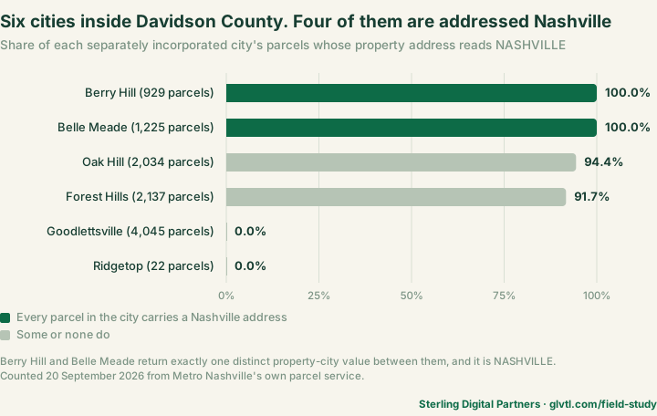
Oak Hill and Forest Hills are nearly as bad — 94.4% and 91.7% — and their remaining parcels are not addressed to their own cities either. They are addressed BRENTWOOD, a city in the next county. Goodlettsville and Ridgetop break the pattern for a mundane reason: Goodlettsville has its own postal identity, so its parcels are addressed Goodlettsville. Which produces the last twist.
Is any city addressed as a different city entirely?
Yes. Every one of the 22 parcels in the city of Ridgetop is addressed GOODLETTSVILLE — a separate incorporated city, which is not the one they are in. Ridgetop is the smallest of the six and straddles the Davidson–Robertson county line; the Davidson County portion of it is 22 parcels, and the record addresses all 22 to a neighbour. So the address column in this county can name the wrong city in two different ways: it can name the metropolitan government that does not govern the parcel, or it can name another small city down the road.
A worked example: 2600 8th Ave S, parcel 189497. A strip shopping centre on 7.03 acres, appraised by Davidson County at $72,310,000 for 2026, land use code 022, “STRIP SHOPPING CENTER”. Its property address, as the county record prints it, is 2600 8TH AVE S, NASHVILLE. Its tax district, in the same row of the same record, is BH — the City of Berry Hill.
Two more on the same street pattern: parcel 166108 at 2350 8th Ave S, a high-rise apartment building appraised at $74,250,000, and parcel 452197 at 2604 Fessey Park Rd, a low-rise apartment complex on 9.01 acres appraised at $78,235,800. Both addressed NASHVILLE. Both in Berry Hill.
Why this costs money rather than merely being untidy. A commercial property in Berry Hill is subject to Berry Hill’s zoning, Berry Hill’s codes department and Berry Hill’s permitting. Anyone who reads “Nashville” off the address and goes to Metro for a zoning answer is asking the wrong government about a $72m building. The record will tell you — but only if you read the tax district column rather than the address, and nothing on the address column warns you.
And it is not the tax bill that gives it away. This is the part that surprised us and it is worth stating against the obvious assumption: Berry Hill levies no city property tax at all. Neither do Forest Hills or Oak Hill. The Tennessee Comptroller’s 2025 Tax Aggregate Report tabulates every municipal property tax rate in the state, and those three cities appear nowhere in it — while Belle Meade appears at $0.3011 per $100 of assessed value on top of the county’s $2.7820, Goodlettsville at $0.5068 and Ridgetop at $0.3490. The Davidson County Assessor’s own wording anticipates this exactly: properties in the satellite cities pay the county rate “plus the satellite city’s rate, if any.”
So a Berry Hill owner’s tax bill looks like a Nashville owner’s, and their address says Nashville, and neither of those facts tells them that their zoning, their permits and their codes enforcement come from a different city government. The only column in the record that does is TaxDist.
All figures for all three parcels read from the Metro Nashville parcel service on 20 September 2026: ParID, PropAddr, PropCity, TaxDist, LUCode, LUDesc, TotlAppr and Acres. These are individual parcel readings and are not among the 101 counted figures in the CSV.
Are the addresses themselves reliable?
On 9,405 parcels there is no address to be unreliable. 3.3% of the county’s parcels carry the placeholder house number 0 — an address of the form “0 SOME ROAD”, which is the record’s way of saying it has a street but no number. A further 51 carry no house number at all. And 9,332 parcels share a property address with at least one other parcel, against 279,690 distinct addresses on the roll.
That last figure is the interesting one, because it is low. In Mecklenburg County the same measurement ran far higher and produced a whole finding; here it is 3.3% and it does not. We are publishing it as a number that did not travel, because a pattern that holds in three markets and fails in the fourth is worth more than a pattern quietly dropped when it stops being impressive.
Finding 02 / The whitespace
15% of the county is invisible to a query for its own tax district.
How many tax districts does Davidson County have?
Fifteen. The column holds twenty-two values. The difference is entirely whitespace: USD and USD are stored as different strings, and so are GSD , GO , BH , FH , OH and BM . 43,132 parcels — 15.0% of the county — carry a tax district with trailing spaces.
This is the most dangerous kind of data defect, because it does not announce itself. A filter for TaxDist = 'USD' returns a large, plausible-looking set of parcels and silently omits 34,046 of them, 17.8% of that district. No error, no warning, no empty result to make you suspicious. Just a number that is one-sixth too small.
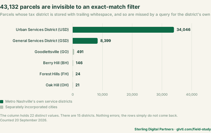
Berry Hill is the sharpest case in proportional terms: 146 of its 929 parcels, 15.7%, are stored as BH . So a study that asked this record how big Berry Hill is, without trimming, would have answered 783 — and every percentage in finding 01 would have been computed against the wrong denominator while still looking entirely reasonable.
Check it yourself
Before you filter any text column in a county record, count its distinct values twice: once raw, once trimmed. If the two numbers differ, every exact-match filter you write against that column is lying to you by the difference. It costs one query. In this record it is the difference between 22 districts and 15.
The same check catches the other half of the problem, which is case. Here the district codes are consistently upper case, so trimming is enough. That is luck rather than design, and it is not true of every column in every county — study No. 05 found a class code whose description arrives in two different letter cases, splitting one category into two.
Finding 03 / The label
91 land use codes, 89 descriptions. The label both splits codes and merges them.
Can you group Davidson County parcels by their land use description?
No, and it fails in both directions at once. The record carries a code, LUCode, and a human-readable description, LUDesc. The description is the one everybody reaches for, because it is legible. There are 91 distinct codes and only 89 distinct descriptions, which is already impossible if the two were in step.
Merging. Five descriptions are each shared by two different codes:
| Description | Codes | Parcels |
|---|---|---|
| SINGLE FAMILY | 011 and 081 | 156,791 |
| RESIDENTIAL CONDO | 015 and 086 | 55,182 |
| DUPLEX | 012 and 082 | 7,088 |
| VACANT RURAL LAND | 080 and 80M | 3,203 |
| MOBILE HOME | 018 and 088 | 426 |
These are not duplicates. They are the urban and rural halves of the same classification. Davidson’s code set runs in decades — 01x is urban and suburban residential, 08x is rural — and the assessor’s own labels give it away where the description is unique: 085 is FARM BUILDINGS ONLY and 089 is RURAL COMBO, the exact parallel of 019 RESIDENTIAL COMBO/MISC. The five shared descriptions are precisely the five urban/rural twins. The acreage confirms it: parcels coded 081 have a median of 4.04 acres against 0.25 for 011.
So grouping on the description merges a rural classification into an urban one on 156,791 parcels for “SINGLE FAMILY” alone. The assessor separated them deliberately; the label puts them back together.
We first guessed the 08x block was Tennessee’s greenbelt program and we were wrong, which is worth recording. Greenbelt requires a 15-acre minimum under the State Board of Equalization’s greenbelt manual, and only 13.9% of 08x parcels reach it. Greenbelt is also an assessment-program status granted on application, not a land use classification, and there is no greenbelt field in this layer at all.
Splitting. Three codes are written under more than one description, because of misspellings. Code 010 appears as both VACANT RESIDENTIAL LAND and VACANT RESIENTIAL LAND, the latter on 1,182 parcels. Code 077 appears as TERMINAL/DISTRIBUTION WAREHOUSE and TERMINAL/DISTRIBUTION WARHOUSE — and the misspelling is the majority spelling, on 619 of that code’s 625 parcels. Code 036 splits on a double space.
Search this record’s land use descriptions for “RESTAURANT” and you will find none. All 446 of them are spelled RESTURANT.
That last one does not split a code, because the misspelling is perfectly consistent — every single parcel on code 051 carries it. Which makes it worse, not better: a split at least leaves half your results visible. A uniform misspelling returns zero and looks like an answer.
Is the code column safe to group on?
Yes, with one warning: it is not a number. LUCode is a zero-padded string. Single family is 011, office is 032, warehouse is 064. Cast it to an integer and 011 becomes 11, which will not match anything you compare it against; write a range comparison like LUCode BETWEEN 30 AND 40 and you will get zero rows and no error. And one value in this county is 80M, which is not numeric at all and will raise or silently drop depending on what you are using.
So: group on LUCode, always, and treat it as text. Every figure on this page that involves land use does exactly that, and the script says so at the top.
Finding 04 / The classification
A Nashville duplex becomes commercial property the moment its owner moves out.
How is Tennessee property assessed?
At a percentage of appraised value fixed by the state constitution. Tennessee does not tax property on market value; it taxes a fraction of it, and the fraction depends on the constitutional subclass. Tenn. Const. art. II, §28 sets industrial and commercial property at 40%, residential and farm property at 25%, and public utility property at 55%. The Comptroller and the Davidson County Assessor both publish the same table.
Which makes the classification readable straight out of the data, without trusting any label: divide assessed value by appraised value and the quotient is the subclass. Davidson County obliges — 235,751 parcels sit at precisely 0.25 and 29,676 at precisely 0.40, with 18,759 carrying an appraised value but assessed at zero and only 666 at any other ratio at all. Every “commercial” figure on this page is defined that way, because finding 03 is the reason not to trust the land use code with it.
Why are 4,799 duplexes assessed as commercial property?
Because the constitution says they are, and the rule counts rental units rather than dwellings. The clause is in the middle of the residential subclass and it is easy to read straight past:
“Residential Property, to be assessed at twenty-five (25%) per cent of its value, provided that residential property containing two (2) or more rental units is hereby defined as industrial and commercial property.”
Tenn. Code Ann. §67-5-501(11) restates it: residential property “contains not more than one (1) rental unit”, and anything used for dwelling purposes with two or more rental units “is defined and shall be classified as ‘industrial and commercial property’”. So an owner-occupied duplex has one rental unit and is residential. A fully rented duplex has two and is commercial. Same building, same land use code, two different constitutional classes, and the thing that moves it is whether the owner lives there.
The Tennessee Attorney General answered this precise question in Opinion 25-016, issued 25 August 2025 — thirteen months before we counted. Asked how to classify “a duplex where one half is rented and the other half is occupied by the owner”, the Attorney General answered that it “generally will be classified as residential… the property contains only one rental unit”.
Does the county’s data actually behave that way?
With a precision that is genuinely striking, yes. If the rule is really a count of rental units, the split should appear at the duplex and essentially nowhere above it — because a duplex is the only structure where an owner moving in can drop the rental count to one. A triplex with an owner in residence still has two rented units. We ran the ladder:
| Code | At 25% residential | At 40% commercial |
|---|---|---|
011 SINGLE FAMILY | 148,423 | 1,030 |
012 DUPLEX | 2,045 | 4,799 |
013 TRIPLEX | 3 | 342 |
014 QUADPLEX | 0 | 235 |
Single family is almost entirely residential. The duplex splits. Above it the residential side empties out: three triplexes against 342, and for the quadplex not a single parcel at the residential ratio — zero, against 235. The break appears at exactly the structure type the constitutional rule predicts, and nowhere else on the ladder. That is the rule operating, visible in a county’s own arithmetic.
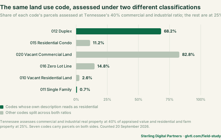
We tested it a second way. The record carries the owner’s mailing address beside the property address, which is a rough proxy for owner-occupancy. Among duplexes assessed at 25%, the two addresses match on 65.9% of them. Among duplexes assessed at 40%, they match on 5.6%. A mailing address is not a determination of residence and we are not presenting it as one — but it points hard in the direction the statute predicts.
So can you read owner-occupancy off the assessment ratio?
No, and the Attorney General forecloses it explicitly. This is where a good finding turns into a wrong one if you push it a step too far. The same opinion continues: “there is no bright-line rule that a single-family, stand-alone home or an owner-occupied duplex will always be classified as residential”, and directs assessors to weigh “all the facts and circumstances”. In Spring Hill, L.P. v. State Board of Equalization the courts classified 44 detached single-family houses as commercial because they were one development under common ownership — which is very likely part of what those 1,030 commercial “SINGLE FAMILY” parcels are.
The term “rental unit” is also nowhere defined in the statute. And there is a short-term-rental carve-out at §67-5-801(b)(2) that presumes residential classification for an owner’s principal residence with not more than one rental unit, which matters in Nashville more than almost anywhere.
So the honest formulation is the aggregate one. Across thousands of parcels the classification tracks the rule with precision. On any individual parcel it does not tell you who lives there. This page reports the pattern and makes no claim about any single property.
If you are underwriting a Nashville duplex, the land use code reads DUPLEX either way, and the assessed base differs by 60%. Nothing in the record announces which one you are looking at — you have to divide two columns and know why.
Finding 05 / The dates
Two date columns. They disagree on 91.2% of parcels, and one runs back to 1849.
Which column holds the date a Davidson County property last changed hands?
OwnDate. Not PropDate, which is the one that sounds right. The record carries both, both are populated on 287,061 parcels, and they disagree on the year for 261,740 of them — 91.2%. This is not a rounding difference or an edge case. It is nearly every row in the county.
PropDate runs back to 1849, with 32 parcels dated before 1900. OwnDate runs back to 1854. Whatever PropDate is tracking — and the record does not document it — it is not the transfer that put the current owner on the parcel. OwnDate moves with OwnInstr, the instrument number, which is what ties a row to a recorded deed.
Filter this record by the wrong date column and nine out of ten of your rows are wrong. Nothing will tell you. The query runs, the results look like dates, and the answer is fiction.
We walked into this ourselves while scouting the market, which is the only reason it is a numbered finding rather than a footnote. Every date-filtered figure on this page uses OwnDate, and count_nashville.py carries the warning in its header docstring so that anyone reusing the script inherits it.
Finding 06 / The sale record
Two in five commercial parcels have no sale price, and the field named ValidSale is populated four times.
ValidSale is populatedWhat did Davidson County commercial property sell for?
On 12,478 of 29,676 commercial parcels — 42.0% — the record does not say. There is no price in the row at all. Of the 17,198 that do carry one, the most common sale code is Q, on 41.1% of them, and what Q means is not published anywhere we can find.
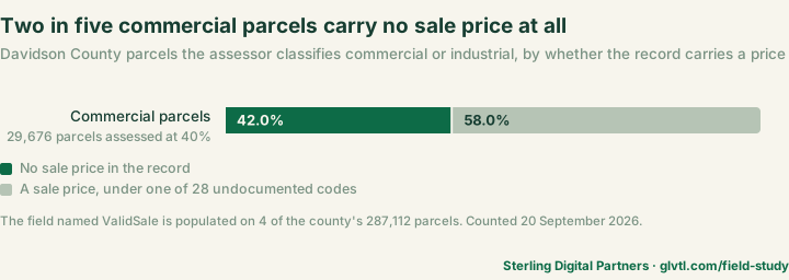
Restrict it to parcels that have actually moved recently — the 12,595 commercial parcels whose OwnDate falls in 2021 or later — and the share coded Q drops to 23.7%, with I and U becoming the two largest codes instead. Something changes in how recent transfers are coded, and the record offers no way to find out what.
Is there a field that says whether a sale was valid?
There is a field named exactly that. It is populated on four parcels. ValidSale carries a value on 4 of Davidson County’s 287,112 parcels — three read Y, one reads N. The other 287,108 are empty. It is not a broken field so much as an abandoned one, and its name is the problem: anyone writing a query against this record will find it, reasonably assume it is the sale-qualification flag, and build a filter that returns four rows out of a quarter of a million.
The working qualification information, such as it is, sits in SaleCode — 28 distinct codes across the roll, with 14,499 parcels carrying none. We can count them exactly. We cannot tell you what any of them means.
Is there a published legend for these codes?
Tennessee publishes one. Davidson County is not using it. This is the part that took the longest to establish and it is the more interesting answer. The Comptroller’s Division of Property Assessments publishes a Sales Data Collection and Verification Manual, approved by the State Board of Equalization, whose Appendix C sets out the accept and reject codes for warranty deeds: A accepted, B family sale, C cemetery sale, E partial interest, F tax exempt, G forced sale, H business or corporate, I financial institution, J estate sale, K right-of-way, M physical difference, N non-arm’s-length, P multiple parcels, R personal property, T timber or mineral.
Now compare Davidson County’s actual distribution. Its single most common sale code is Q, on 144,427 parcels — slightly over half the county — and Q does not appear in the state’s code set at all. Neither do D, L, O, S, U, V, W or X, all of which Davidson uses. Meanwhile the state’s own accept code, A, appears on 13 parcels in the entire county.
There is a reason, and the Comptroller states it plainly: Davidson is one of nine Tennessee counties that “do not participate in the state’s IMPACT CAMA system”. It runs its own system with its own codes. Which means anyone who finds the state manual — the obvious thing to do — and maps its letters onto Davidson’s column will produce confident, specific, wrong answers. M and N and K all exist in both sets. There is no reason to believe they mean the same thing in both, and no document that says they do.
A code set that partially overlaps a published standard is more dangerous than one that does not overlap at all, because the overlap is what makes the mapping look safe.
Does the county document the field anywhere?
It publishes a data dictionary, and the field is not in it. Metro’s parcel metadata document — version 2.0, last updated 16 October 2023, reachable only through the ArcGIS item description rather than from any page on nashville.gov — documents more than forty fields. SaleCode, SaleSrc and ValidSale are not among them. The nearest entry defines a neighbour: “Land Use Code | Text | General Land Use Code assigned by the Assessor of Property.”
Three rows of that dictionary, where the assessed-value definitions should be, still contain the unfilled Microsoft Word template placeholder: “Land Assessed Value | Number | Click or tap here to enter text.”
And the three code fields are not on the county’s public parcel layer at all. The hosted feature service behind Nashville’s open data portal omits all three from its schema; they exist only on the internal map server this study reads. They are undocumented and unpublished at once, and they surface only if you go around the front door.
We looked in the places a legend would be: the service and layer metadata, where every field returns a null domain; the ArcGIS item, its resources and its ISO metadata; the county’s open data portal; the Assessor’s site and its search; the Assessor’s own public sales reports, which drop the codes entirely and print plain English “Yes”/“No” columns instead; and the Comptroller’s greenbelt, commercial listing, board-of-equalization and sales manuals. Two places remain unchecked because they refuse automated requests: the state’s TPAD portal and the Assessor’s session-bound parcel pages. We say that rather than claim a completeness we have not earned, and we have written to the Assessor to ask.
A field called ValidSale that is blank 99.9986% of the time is worse than no field at all, because it answers a question you were right to ask.
When you do this weekly
Read the district, not the address. Then read the code, not the label.
Every trap on this page is a column that looks like the answer and is not. The address names a city that does not govern the parcel. The field named ValidSale is empty. The date column with the better name is the wrong one. The readable land use label merges two codes. None of them errors; all of them return something plausible.
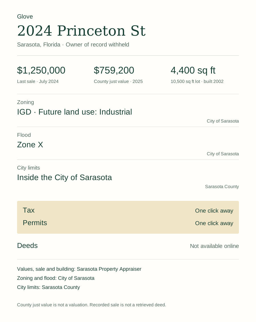
Glove does the same digging in one call, inside Claude Code, Cursor or Codex — parcel, the value type the county reports with its year, last sale, zoning, flood and city limits, each number carrying the page it came from. Recorded documents and permits are still yours to click.
Five free packets. Each successful packet uses one credit.
Works in Claude Code, Cursor and Codex.
Method, and what these counts do not establish
Source
One public ArcGIS REST service, read on 20 September 2026: maps.nashville.gov/arcgis/rest/services/Cadastral/Parcels/MapServer/0, the layer Metro Nashville names “Ownership Parcels”. 287,112 parcels, 56 fields, no key, no login, no fee and no rate limit. The extract was paged with a stable sort, de-duplicated on the object identifier and reconciled against the service’s own returnCountOnly before any figure was computed; count_nashville.py exits rather than print a number if that reconciliation fails.
The record is rebuilt nightly, and what to anchor to instead
Nothing on this page can be reproduced for a past date from this source by anyone, including us. The parcel layer is regenerated on a nightly cycle and carries no archived snapshot, so a reader running the script next month will get next month’s county, not this one. That is why the counts CSV is published beside the script rather than only the script: the CSV is the dated artifact, and the script is the proof of how it was made.
There is, however, a properly static source in this county and it deserves to be better known. The Davidson County Property Assessor publishes quarterly sales workbooks — on our count 1,428 files in Excel and PDF, covering 2021 to mid-2026, each month cut eleven ways by geography. They are versioned by URL, dated, and they will still say the same thing in a year. Their columns are Parcel ID, Land Use, Property Address, Suite/Condo #, Property City, Sale Date, Sale Price, Legal Reference, Sold As Vacant and Multiple Parcels Involved, and the Assessor warns that they “should not be considered a complete listing of sales for the given month” because of late recordings.
Note what those workbooks do not carry: any sale code. The Assessor’s public-facing product spells the flags out in plain English — “Yes” and “No” columns — and never exposes the coded field at all. Which is finding 06 from the other direction.
Reappraisal, and why the 2025 values look the way they do
Davidson County runs a four-year reappraisal cycle and implemented its most recent reappraisal in 2025 — three years of visual inspection followed by revaluation in the fourth. The appraised values every figure on this page divides by are therefore one year old, not stale. The previous cycles ran 2021, 2017, 2013 and 2009.
A reappraisal in Tennessee does not automatically raise taxes: the certified tax rate law requires a jurisdiction to recompute a revenue-neutral rate, and to hold a public hearing before exceeding it. In Davidson County in 2025 the mechanism ran and the rate went up anyway — the Assessor records that the revenue-neutral General Services District rate of $1.995 was raised by the Mayor and Metro Council to $2.782, which she describes as a 39% rate increase. We mention it because a reader looking at 2025 Davidson values should know both halves of that.
One caution on dates. The Assessor’s reappraisal page describes a four-year cycle implemented in 2025, while the FAQ on the same site says the next countywide reappraisal will occur in 2028 — a three-year interval, which matches no cycle in the statute. We have not resolved which is right and we do not assert a next reappraisal year.
Definitions
Commercial. Every “commercial” figure here means a parcel assessed at 40% of its appraised value — Tennessee’s statutory ratio for commercial and industrial real property. It is the assessor’s own classification, read out of two columns of the county’s own record. We deliberately do not use the land use code for this, and finding 03 is the reason: the code column is sound but the description column is not, and finding 04 shows the code does not track the classification anyway. Anyone preferring a code-based definition will get different numbers, legitimately.
Tax district. The TaxDist column, trimmed of whitespace before comparison. Untrimmed it holds 22 values for 15 districts; see finding 02. The six separately incorporated cities are BH, BM, FH, OH, GO and RT. GSD and USD are Metro’s own General and Urban Services Districts and are not separate municipalities; CBID, GBID, MBID, SNDG and SNDU are business improvement and special districts and are excluded from the city counts for the same reason.
Transfer date. OwnDate, never PropDate. Finding 05.
Land use. LUCode, treated as a string, never LUDesc and never cast to a number. Finding 03.
What this is not
It is not a claim that anyone has been misclassified or misassessed. Finding 04 counts parcels whose land use code and statutory classification disagree and states plainly that the record does not say why, and that ordinary use-based reasons could account for all of it. Nobody should quote those figures as a count of errors, because they are not one.
It is not a claim about Nashville’s tax burden. Nothing here compares tax rates, bills or levies between Metro and the six separate cities. Finding 01 is about which government has jurisdiction over a parcel, not about which one is cheaper.
It is not a count of sales. The figures in finding 06 count parcels and the sale information attached to each parcel’s current ownership row, which is one transfer per parcel. It is not a transaction history and it will not match a deed-book count.
It does not cover the Nashville metro. This is Davidson County only. The metropolitan statistical area runs to thirteen counties and most of the region’s recent commercial growth is in Williamson and Rutherford, neither of which is counted here.
Outstanding, and stated rather than hidden
The sale codes have no published legend. Davidson County uses a local code set — 28 distinct values including Q, I, U, M, V, C, S and D — rather than a statewide one, and we have not found a county or state document that defines them. This page therefore counts the codes and names none of them. We have written to the Davidson County Property Assessor to ask; if a legend arrives, this section gets rewritten and the page re-dated.
The 08x land use family is undocumented too. Codes 080, 081, 082, 086, 088 and 80M share their descriptions with ordinary residential codes while carrying systematically larger acreage. We can measure the difference and we cannot explain it, so finding 03 reports the measurement and offers no interpretation.
The three misspellings are VACANT RESIENTIAL LAND on code 010, TERMINAL/DISTRIBUTION WARHOUSE on code 077 and RESTURANT/CAFETERIA on code 051. They are reported because they change what a text search returns, not to score a point; every record of this size has typos in it and most counties never hear about them. If Metro corrects them we will re-run the counts.
Source attribution, as Metro requires it
Metro Nashville’s open data policy, issued by executive order, sets three conditions on secondary use of its data, and we would rather meet them visibly than bury them. The figures on this page and in the counts CSV are derived from Metro Nashville and Davidson County parcel data (MetroGIS; Nashville Planning Department and Assessor of Property), retrieved on 20 September 2026 from https://maps.nashville.gov/arcgis/rest/services/Cadastral/Parcels/MapServer/0. The aggregate figures and the analysis are ours and are licensed CC BY 4.0; the underlying parcel data is not, and no intellectual property right in it passes to anyone through this page. The Metropolitan Government provides that data as is, for informational purposes only. This analysis is not approved or endorsed by the Metropolitan Government of Nashville and Davidson County.
Nothing on this page or in the CSV republishes Metro’s parcel records. What we publish are counts computed from them — totals, shares and distinct-value counts — together with a handful of individually cited parcels named in the worked example above.
Reproduce it
Download count_nashville.py and run it. Standard library only, no dependencies, no key. It pulls the county, reconciles the extract against the advertised count, prints all 125 figures and writes the CSV published beside it. make-charts.py draws the four charts on this page and reads every plotted value from that CSV rather than from anything typed in by hand — if a number is not in the CSV it raises instead of drawing it. Because the source is rebuilt nightly, expect your run to differ from ours; the CSV is what this page quotes.
Cite this study
Klebl, Chris. “Every parcel in Berry Hill is addressed Nashville.” Sterling Digital Partners, field study No. 06, 20 September 2026. https://glvtl.com/field-study/nashville-commercial-record/
Link to a finding
<a href="https://glvtl.com/field-study/nashville-commercial-record/#f1">All 929 parcels in the city of Berry Hill, Tennessee carry a Nashville property address</a>
The four charts are free to embed; each carries its own snippet above, in PNG and SVG. The counts CSV and both scripts are published under CC BY 4.0 — reuse them anywhere with a link back.
Corrections
If a count looks wrong, tell us with the metric name and the public source. We will re-run it and re-date the page.
Looking up a Davidson County record yourself? The Nashville records directory lists every official source we have checked there, with the date a person opened it and what trips people up.
The series
This is the sixth of ten, and the first in Tennessee. No. 01 counts Sarasota and Manatee; No. 02 counts Miami-Dade, where 77.4% of addresses that mail as “Miami” are not in the City of Miami; No. 03 counts Mecklenburg County, North Carolina; No. 04 counts Harris County, Texas; No. 05 counts the Charleston tri-county. Read study No. 02 against this one: in Miami the postal city is simply wrong, while in Davidson County the address names a real government that genuinely is not the one in charge. The rest are listed on the field studies index, where you can ask to be told when your market lands.