Glove / Field study No. 02
Three in four Miami addresses are not in Miami.
We counted Miami-Dade County’s property record — 938,308 parcels, 56,907 of them commercial or industrial — looking for the places where the record says one thing and means another. The jurisdiction trap here is the largest we have measured anywhere, and the money behind the assessment cap runs to eleven figures.
Share or cite:LinkedInXCite, link or embed ↓
Finding 01 / Jurisdiction
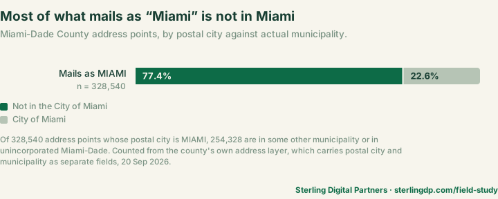
Most of what mails as “Miami” is not in the City of Miami.
Miami-Dade County keeps an address layer that carries the postal city and the actual municipality as two separate fields. Query it and the gap is immediate: 328,540 address points give MIAMI as their postal city, and 254,328 of them are somewhere else — in one of seventeen other municipalities, or in unincorporated Miami-Dade.
The county is not hiding this. Its own roll prints “Unincorporated County” in the city field for 395,369 parcels, 42.1% of everything it assesses. The unincorporated area has more than a million residents; the county notes that if it were declared a city it would be the largest in Florida. A million people whose mail has to say something, and what it says is Miami.
Take the postal city as the jurisdiction here and you will be wrong three times in four — wrong about the zoning code, the permit office, the impact fees and who answers the phone.
Check it yourself
The first two digits of a Miami-Dade folio number are the municipality. The Property Appraiser publishes the chart and states it plainly: “Code 30 indicates properties in Miami-Dade County not within the municipality, otherwise referred to as ‘unincorporated.’”
The address layer is public and answers a URL. Query it for MAILING_MUNIC against MUNIC_NAME and you will reproduce the count above.
Finding 02 / The cap
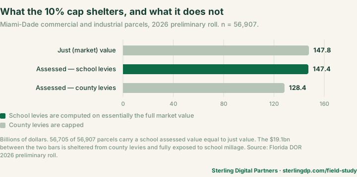
Nineteen billion dollars is capped for the county and uncapped for the schools.
Florida caps annual assessment increases on non-homestead property at 10%. What the cap does not cover is school millage, which is computed on market value. Miami-Dade’s roll publishes both figures, so the difference can be counted rather than argued about.
Across 56,907 commercial and industrial parcels, just value totals $147.8bn. Assessed value for county levies totals $128.4bn — the cap doing its work. Assessed value for school levies totals $147.4bn, which is 99.7% of market. 56,705 of 56,907 parcels carry a school assessed value exactly equal to just value.
$19.1 billion of commercial value is sheltered from the county and fully exposed to the schools. If you model a Miami-Dade tax bill off the capped number, you have modelled the smaller half.
A Florida court has already priced this mechanism, in this county. In S and A Property Investment Services, LLC v. Garcia, owners of a Miami property moved it by quitclaim deed to a company they wholly owned, with no money paid. The then-Property Appraiser treated that as a change of ownership and removed the cap: assessed value rose from $104,023 to $273,409 in a single year. The Third District affirmed in March 2023.
Fla. 3d DCA, No. 3D22-835, 15 March 2023. Pedro J. Garcia was Property Appraiser at the time; Tomás Regalado has held the office since January 2025.
Finding 03 / Comparable sales
Nearly half the recorded commercial sales are not arm’s-length.
Of 4,614 sales recorded against commercial and industrial parcels from 2025 onward, 2,129 carry a Department of Revenue disqualification code. The largest single group is code 11 — corrective deeds, quit claims, tax deeds and transfers where no documentary stamps were paid. There are 1,338 of those, nearly one sale in three.
That is the same instrument the court priced above. The deed that removes an owner’s assessment cap is the deed that quietly ruins your comparables.
Is nearly half unusual? No. Non-arm’s-length transfers are a normal part of every county’s record. Sarasota runs 47.1% on the same window and Manatee 55.5%. That is the point. It is not a Miami problem, it is a public-record problem, and it is why the codes exist.
Read the prices without reading the codes beside them and roughly two in five of the numbers in front of you are not comparable sales.
Check it yourself
Every sale row carries a qualification code. Treat anything outside 01–07 as a transfer rather than a sale until you have read the deed. The code list ships with the state’s own sale data file.
Finding 04 / Property match
1,280 addresses return more than one property if you drop the direction.
Miami-Dade’s grid runs NW, NE, SW and SE off a single origin, so the direction is not decoration — it is most of the address. Across 886,549 combinations of house number, street and ZIP, 1,280 resolve to two or more directional prefixes, covering 2,566 parcels.
The commercial slice is small and sharp: 20 keys, 40 parcels — and the two records at a colliding address can be nothing alike. 9201 E Bay Harbor Dr and 9201 W Bay Harbor Dr, both in 33154, are both one-story stores in Bay Harbor Islands — same street, same ZIP, same municipality, same DOR use code. The county puts just value at $15,752,100 on the east parcel and $3,231,200 on the west. Folios 13-2227-001-0170 and 13-2227-001-3180.
Sometimes they are not even the same kind of property. At 4 Krome Ave in Homestead 33030, the north parcel carries DOR use code 033 and a just value of $1,390,000; the south parcel carries code 028 and $16,700,000. One letter, twelve times the number.
This is the failure that does not announce itself. A record comes back, it looks right, and it belongs to a different building.
Check it yourself
Confirm the full situs and the folio against your subject before copying a field. If a direction is missing from the address you were handed, go back and ask for it. A returned result is not a match.
A note on method: we count directional prefixes only — N S E W NE NW SE SW as the county abbreviates them, in the position before the street name — which is the metric used in study No. 01. A full word in the trailing position, as in 60 EDGEWATER DR NORTH, is a condominium wing label sharing a column with 3A and PH1C; those are not counted. Counting every address that maps to more than one parcel would mostly count condominium units, which is an artifact of ownership structure rather than a trap. The script carries the rule.
When you do this weekly
Four checks, every property, before you say a number out loud.
All four are catchable by hand. Miami-Dade publishes enough for a careful person to do it, and the county’s address layer is better than most. It takes time you may not have on every address.
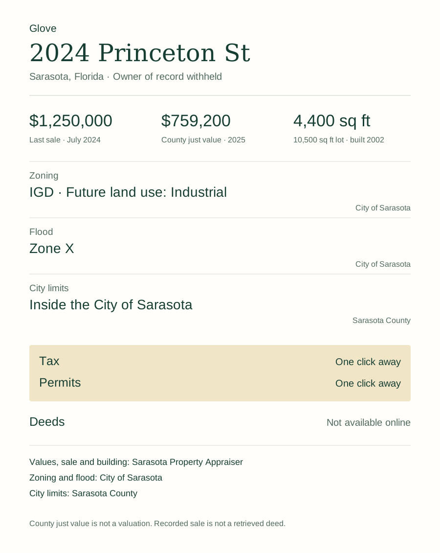
Glove does the same digging in one call, inside Claude Code, Cursor or Codex — parcel, the value type the county reports with its year, last sale, zoning, flood and city limits, each number carrying the page it came from. Recorded documents and permits are still yours to click.
Five free packets. Each successful packet uses one credit.
Works in Claude Code, Cursor and Codex.
Method, and what these counts do not establish
Source
Two sources, both public and both free. The roll is the Florida Department of Revenue’s 2026 preliminary assessment roll for Dade County (number 23): NAL23P202601.csv for parcels and values, SDF23P202601.csv for sales, from the PTO data portal (direct: NAL, 56.7 MB, SDF, 1.9 MB). The files were generated 1 July 2026, published 27 July 2026, and downloaded and counted on 20 September 2026. Jurisdiction counts come from Miami-Dade County’s own address layer, queried live on the same date.
Every figure above is recomputed by count_miami.py, standard library only, no install step. python3 count_miami.py downloads both rolls and queries the address layer; pass two paths to count files you already have.
The Miami-Dade Property Appraiser does not publish the roll free; its bulk service charges from $50. The state publishes the same submitted files at no cost, which is what we used.
Definitions
- Commercial or industrial — Department of Revenue use code 010–049, as printed in
DOR_UC. 56,907 of 938,308 parcels. - Assessed —
AV_NSDis the non-school basis andAV_SDthe school basis. Both are published here, so finding 02 is measured rather than inferred. - Qualified sale — codes 0 and 01–07. Everything else is counted as not qualified.
- Address key — house number, street name and five-digit ZIP, compared with the directional prefix removed.
- What is left out — the Department groups use code 003, multi-family of ten units or more, under Commercial. These counts use 010–049 and exclude it.
What this is not
- It is a count of a preliminary roll, submitted 1 July 2026 and not yet certified. Values move at certification. A later file will not reproduce these numbers exactly.
- The sale file covers 2025 and 2026 only — one roll cycle, not a history. Where other counties are named, all three are cut to the same window.
- A disqualification code means the appraiser did not treat the transfer as an open-market sale for roll purposes. It is not a finding about the parties.
- Nothing here is a survey, a valuation, a title search, a zoning determination or a permission for a proposed use.
- No owner name, mailing address, grantor, grantee or legal description is reproduced.
Reproduce it
The counts are published as a CSV with source, date and denominator on every figure. The jurisdiction figures can be reproduced in a browser against the county’s address layer without any code at all.
Cite this study
Klebl, C. (2026). Three in four Miami addresses are not in Miami. Sterling Digital Partners. Retrieved from https://glvtl.com/field-study/miami-commercial-record/
Link to it
<a href="https://glvtl.com/field-study/miami-commercial-record/">Three in four Miami addresses are not in Miami</a>, Chris Klebl, Sterling Digital Partners, 2026.
Corrections
If a count looks wrong, tell us with the metric name and the public source. We will re-run it and re-date the page.
The series
This is the second of ten. Study No. 01 counts Sarasota and Manatee. The rest are listed on the field studies index, where you can ask to be told when your market lands.